CS 2019.02.01.12
Files > Conference Series > 2019 > Humboldt Kolleg 2019
Bionatura Conference Series Vol 2. No 1. 2019
“Breaking Paradigms: Towards a Multi-, Inter- and Transdisciplinary Science” In commemoration of the 250th Anniversary of Alexander von Humboldt
Geometry of Cauto-Guacanayabo basin, Cuba

Yaniel Misael Vazquez Taset
Disponible en: http://dx.doi.org/10.21931/RB/CS/2019.02.01.12
ABSTRACT
The Cauto-Guacanayabo basin is located in the southern part of the Guacanayabo-Nipe tectonic corridor, Eastern Cuba, and records the evidence of the evolution of the Cuban Orogen. The objective of this work is to determine the geometry of the sedimentary infill of the basin, as well as the relationship between the units that constitute it. This study is based on the interpretation of several 2D seismic lines, geological data of surface and boreholes. Four tectonosequences have been defined (TSA, TSB, TSC, TSD) delimited by four regional unconformities in the basin (U-0, U-1, U-2, U-3). The TSA is formed by Charco Redondo, Puerto Boniato, Farallón Grande and San Luís formations, with ages from the middle Eocene to the upper Eocene. The Sevilla Arriba, Paso Real, Camazán and Güines formations constitute the TSB; its age varies between the upper Oligocene and the middle Miocene. The TSC covers a period of age between the middle Miocene and the lower Pliocene and is composed of the Cabo Cruz and Manzanillo formations. The TSD is formed by the Río Maya, Dátil, Bayamo, Cauto, Jaimanitas, Villarroja, Río Macío, and Jutia formations, and the informal stratigraphic unit Marga Demajagua. The age of this tectonosequence varies between the upper Pliocene and the Holocene. This study brings new knowledge about Cuban synorogenic strike-slip basins. In addition, it allows us to understand how the complexity and compartmentalization of the sedimentary infill of the basin are the results of the evolution of the Cauto-Nipe sinistral strike-slip fault.
Keywords. Cauto-Guacanayabo basin, sedimentary infill, tectonic corridor, strike-slip fault, tectonosequence
INTRODUCTION AND GEOLOGICAL FRAMEWORK
The Cauto-Guacanayabo basin (CGB) is one of the synorogenic sedimentary basins associated with the Guacanayabo-Nipe tectonic corridor (Fig. 1). It occupies the southern part of the tectonic corridor, and like the Cacocum and Nipe basins, it records the tectono-sedimentary evidences of the Cuban orogen’s evolution and the tectonic corridor1,2,3,4,5. The basin is of type polygenetic strike-slip5 and is developed both onshore and offshore (Golfo de Guacanayabo, GG in Fig. 1). The uplift of Lewinston constitutes the structure that limits the northern basins Cacocum and Nipe of the Cauto-Guacanayabo basin. This uplift affects the sedimentary infill and the basement but is barely reflected on the surface.
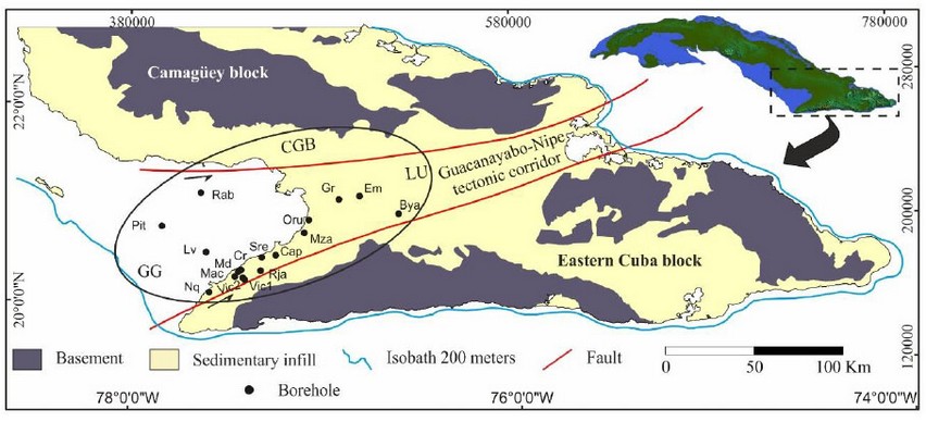
Figure 1. Geological skecth of Central-Eastern Cuba that shows the basement and sedimentary infill. In addition, the Guacanayabo-Nipe tectonic corridor, the Cauto-Guacanayabo basin (CGB), the Guacanayabo gulf (GG), the uplift Lewinston (LU) and the following boreholes are represented: Niquero (Nq), Macaca (Mac), Vicana-1 (Vic1), Vicana-2 (Vic2), Media Luna (Md), Lavandera (Lv), Pitajaya (Pit), Rabihorcado (Rab), Río Tana (Rja), Creciente (Cr), Santa Regina (Sre), Campechuela (Cap), Manzanillo (Mza), Oruita (Oru), Granma (Gr), Embarcadero (Em) and Bayamo (Bya). Modified from6.
The Guacanayabo-Nipe tectonic corridor (Fig. 1), like the rest of Cuba's tectonic corridors1,2,3,4,5, cuts obliquely to the Cuban Orogen and is delimited by sinistral strike-slip faults with west-southwest – east-northeast orientations. It also constitutes the limit of the structural blocks Camagüey and Eastern Cuba7.
The basement of the basins that are associated with the tectonic corridor (including the Cauto-Guacanayabo basin) are part of the Cuban Orogen, and these appear towards the northern and southern part of the basin (Fig. 1). The units of the sedimentary infill appear in the central part. The Cuban Orogen is formed by different units as the Caribbeana8, sequences from the margin of the Bahamas, Cretaceous and Paleogene volcanic arcs, and Ophiolite complex1,2,3,4,5.
All these units are of pre-Middle Eocene ages. The Cretaceous and Paleogene volcanic arcs (and maybe the ophiolites) are part of the basement of the Cauto-Guacanayabo basin1,3,4. The sedimentary infill is constituted by siliciclastic and carbonated formations of continental and marine origin, with ages from the Middle Eocene to the Holocene.
MATERIALS AND METHODS
This research has been carried out by the integration of surface and subsurface data, including geological maps, 17 boreholes, and several 2D seismic lines. The geological maps show different scales (1: 500 000 and 1: 250 000) and have allowed us to evaluate the spatial distribution and the relationship between the geological units that appear at the surface. The boreholes are located onshore and offshore (Fig. 1) and reach depths ranging from a few hundred meters to 3000 meters. These show the thicknesses of the units that are part of the sedimentary infill, as well as their vertical relationships and geometries. The seismic lines (like the boreholes) are distributed onshore and offshore. They have been used to establish the correlation with the boreholes (Fig. 2), define the limits of the tectonosequences, and determine its geometry and extension.

Figure 2. Correlation diagram between one seismic line and the Vicana-2 (Vic2) borehole. It shows the tectonosequences described in the text and the unconformities of its limits.
The information was processed with different software among which we can highlight: Surfer®, Corel Photo Paint X5, and KINGDOM®. These software programs allowed us to integrate, interpret and represent the data and results of the work.
Sedimentary infill
The sedimentary infill of the Cauto-Guacanayabo basin consists of 20 lithostratigraphic units with ages ranging from the Middle Eocene to the Holocene1,3,4, Figs. 3, 4). In it, a series of seismic reflectors have been identified (Fig. 2); it constitute marked stratigraphic horizons. These represent important gaps that correspond to regional unconformities at basin level (U-0, U-1, U-2, U-3 in Figs. 2, 3, 4). The unconformities have allowed dividing the sedimentary infill into four tectonosequences (TSA, TSB, TSC, TSD in Fig. 2).
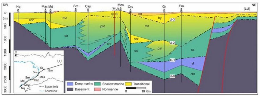
Figure 3. Diagram of longitudinal correlation along the southern margin of the Cauto-Guacanayabo basin between the boreholes Nq, Mac, Md, Sre, Cap, Mza, Oru, Gr and Em. Abbreviation of lithostratigraphic units: chr = Fm Charco Redondo, sl = Fm San Luís, sa = Fm Sevilla Arriba, cz = Fm Camazán, psr =Fm Paso Real, mz = Fm Manzanillo, ccz = Fm Cabo Cruz, by = Fm Bayamo y ca = Fm Cauto. This figure also shows the variations of thickness and geometry of the sedimentary infill, the uplifts of Manzanillo (MU) and of Lewinston (LU), and the unconformities (U-0, U-1, U-2, U-3) that define the tectonosequences of the basin.
The TSA Tectonosequence is limited in its bottom by the basal discontinuity (U-0) and to the top by discontinuity U-1 (Fig. 2). It is made up of the Charco Redondo (chr), Puerto Boniato (pb), Farallón Grande (fr) and San Luís (sl, Figs. 3, 4) formations. It represents an age range between the lower part of the Middle Eocene and the Upper Eocene. It extends throughout the basin and has been cut by the following boreholes: Macaca (Mac), Santa Regina (Sre), Manzanillo (Mza), Oruita (Oru), Granma (Gr), Embarcadero (Em), Bayamo (Bya), Creciente (Cr), Vicana-1 (Vic1), Vicana-2 (Vic2), Rio Tana (Rja), Rabihorcado (Rab), and Lavanderas (Lv, Figs.1, 2, 3, 4). The thicknesses of the Middle Eocene - Upper Eocene (TSA) tectonosequence, cut by the boreholes, vary between 0 meters and 674 meters cut by the Gr borehole (Figs 3, 4). The maximum thicknesses are recorded towards the northeast and in the Gulf of Guacanayabo.

Figure 4. Diagram of transversal correlation for the Northeast part of the Cauto-Guacanayabo Basin, from the Gr borehole and surface geology. Abbreviation of the lithostratigraphic units: chr = Fm Charco Redondo, sl = Fm San Luís, cz = Fm Camazan, psr = Fm Paso Real, mz = Fm Manzanillo, by = Fm Bayamo, ca = Fm Cauto and Rio = Fm Río Macío.
The tectonosequence TSB is limited in its bottom and top by unconformities U-1 and U-2, respectively (Fig. 2). It has an age range that varies from the Upper Oligocene to the Middle Miocene and is formed by Sevilla Arriba (sa), Paso Real (psr), Camazán (cz) and Güines formations (gn, Figs 3, 4). The tectonosequence has been cut by the following boreholes: Rabihorcado (Rab), Lavandera (Lv), Macaca (Mac), Crescent (Md), Crescent (Cr), Vicana-1 (Vic1), Vicana-2 (Vic2), Tana River (Rja), Santa Regina (Sre), Campechuela (Cap), Manzanillo (Mza), Oruita (Oru), Granma (Gr), Embarcadero (Em), and Bayamo (Bya). Its thickness vary between 37 m in the Vic1 borehole and 1337 m in the Cap borehole (Fig. 3). It extends throughout the basin and reaches the maximum thickness towards the south of the basin and in the Gulf of Guacanayabo.
The TSD tectonosequence is limited at its bottom by discontinuity U-3 and at the top by the current erosion surface (Fig. 2). It is formed by the Río Maya (rm), Dátil (dt), Bayamo (by), Cauto (ca), Jaimanitas (js), Villarroja (vr), Rio Maio (Rio) and Jutia (Jt) formations, and the stratigraphic informal unit Marga Demajagua (dmj), with ages from the Upper Pliocene to the Holocene. The TSD extends over a large part of the basin and has been cut by Bayamo (Bya), Embarcadero (Em), Granma (Gr), Oruita (Oru), Tana (Rja), Vicana-1 (Vic1), Vicana-2 (Vic2), Crescent (Cr), Half Moon (Md), Macaca (Mac), Lavandera (Lv), and Rabihorcado (Rab) boreholes. The thicknesses cut by the boreholes vary between 10 meters in the Mac borehole and 518 meters in the Lv borehole, reaching the maximum thicknesses in the northeast part of the basin and in the Gulf of Guacanayabo (Fig. 4).
RESULTS AND DISCUSSION
The sedimentary infill of the Cauto-Guacanayabo basin shows important variations in thickness and in the geometry of the tectonosequences (Figs 3, 4). The most visible variations occur in the southern margin of the basin and in the northeast-southwest direction (Fig. 3). In this zone, the distribution of the thickness is very irregular, as a consequence of the structure and deformation of the basement and part of the sedimentary infill. This structure is the result of the sinistral activity of the Cauto-Nipe strike-slip fault, before and during the accumulation of the sedimentary infill of the basin. However, in a north-south direction the variations and thickness distribution are more regular (Fig. 4). This is because the tectonic control towards the northern margin of the basin is much lower.
The maximum thickness of the sedimentary infill cut by the boreholes reaches 2500 m (Gr borehole) and is recorded in the northeast part of the basin. In that same area, it is located the largest depocenter of the basin.
The internal structure of the Cauto-Guacanayabo basin is defined by a system of uplifted, dropped, and echelon blocks that have controlled the evolution of the sedimentary infill of the basin from the Middle Eocene to the Holocene. This has resulted in a complex and compartmentalized sedimentary infill (Figs 3, 4).
CONCLUSIONS
The geometry, distribution, and thickness of the tectonosequences (TSA, TSB, TSC, TSD) that constitute the sedimentary infill of the Cauto-Guacanayabo basin have varied from the Middle Eocene to the Holocene.
The structure of the basin in blocks has controlled the thickness, the geometry and the distribution of the tectonosequences (TSA, TSB, TSC, TSD).
The maximum thickness of the sedimentary infill is recorded towards the northeast and southwest of the basin.
The most important variations of the geometry and thickness of the tectonosequences are found in the southern margin of the basin, controlled by the Cauto-Nipe strike-slip fault.
REFERENCES
1. Vázquez-Taset, Y.M., Cruz-Orosa, I., Ramos, E., Sàbat, F. (2012). El corredor tectónico Güacanayabo-Nipe: Edad y evolución. Geo-Temas, v. 13, p. 191.
2. Cruz-Orosa, I., Vázquez-Taset, Y.M., Sàbat, F., Ramos, E. (2012a). Las cuencas terciarias de Cuba como registro de la interacción entre diferentes regímenes tectónicos en el noroeste del Caribe. Geo-Temas, v. 13, p. 141.
3. Vázquez-Taset, Y.M., Ramos, E., Sàbat, F., Cabello, P., Cruz-Orosa, I. (2016). Evolución tectono-estratigráfica de la Cuenca Cauto-Güacanayabo, Cuba. Geo-Temas, v. 16(1), p. 48. ISSN 1576-5172.
4. Vázquez-Taset. Y.M. (2017). Estratigrafía de la Cuenca Cauto-Güacanayabo, Cuba. Memorias de VIII Jornadas en Ciencias de la Tierra, Escuela Politécnica Nacional, Quito, Ecuador.
5. Cruz-Orosa, I., Sàbat, F., Ramos, E., Rivero, L., Vázquez-Taset, Y.M. (2012b). Structural evolution of the La Trocha fault zone: Oblique collision and strike-slip basins in the Cuban Orogen. Tectonics. 31, TC5001.
6. Pushcharovsky, Yu., ed., (1988): Mapa Geológico de la República de Cuba. La Habana, Cuba/Moscú, USSR, Academia de Ciencias de Cuba/Academia de ciencias Unión Soviética, escala 1:250 000, 40 p.
7. Rosencrantz, E. and Pardo, G. (1993). An overview of the Cuban Orogen, with an assessment of hydrocarbons potential. Austin, TX, University of Texas Institute for Geophysics, Technical Report 130, 47 p.
8. García-Casco, A., Iturralde-Vinent, M.A., and Pindell, J.L. (2008). Latest Cretaceous collision/accretion between the Caribbean Plate and Caribeana: Origin of metamorphic terranes in the Greater Antilles. International Geology Review, 50: 781-809.
Received: 24 April 2019
Accepted: 21 May 2019
Yaniel Misael Vazquez Taset
School of Earth Sciences, Energy and Environment. Yachay Tech University. Ecuador
Corresponding author: [email protected]